


Nestled between the beautiful lofty ranges of the Himalayas, lies the Naldehra hill station. The blue skies, lush green forests and an occasional rainbow thrown in makes the place look like it has been painted on a canvas.


There could be nothing better than waking up every morning and watch the sunrise from behind the hills. You could have a wonderful time just walking down the meandering roads amidst thick deodar trees and the light mist that covers the trees.


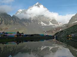
Manimahesh Lake also known as Dal Lake is situated close to the Mani Mahesh Kailash Peak in the Pir Panjal Range of the Himalayas at an elevation of 4,080 metres. It is located in the Bharmour subdivision of Chamba district of Himachal Pradesh.


This place has a religious significance because lake is next to that of the Lake Manasarovar in Tibet. The lake is a chosen pilgrimage trek during the month of August and September corresponding to the month of Bhadon according to Hindu calendar. A popular legend claims that Lord Shiva created Mani Mahesh after he married Goddess Parvati and also performed penance on the banks of Mani Mahesh Lake.


The most popular adopted route is the Bhanrlour-Hadsar-Manimahesh route which involves a 13 kilometers track from Hadsar village to the Manimahesh Lake. Pilgrims also start trekking from Lahaul and Spiti pass through Kugti pass. Those coming from Kangra and Mandi take the Karwarsi pass or Jalsu pass via Tyari village, near Holi in Bharmour. However, the route from Chamba via Bharmour is the easiest one.


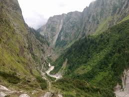
In the Dhauladhar Himalayas rests Triund a ridge which gives a very close look for Moon peak-Indera Pass. Triund is situated 9 kms from Bhagsu Nag which has become very famous trekking destination among tourists from abroad.


From McLeodganj, belonging to upper Dharamsala in Himachal Pradesh, it takes about four hours to reach Triund. Rested at a height of 2827 m, the place is noted for its scenic splendor of the imposing mountainous terrain.


Triund offers a fascinating view of the Dhauladhar ranges and the Kangra Valley. One can trek along alone through this pass without a guide. Because of its proximity to the snowline which is just 13kms away, this region is becoming popular with time. Snow birds and wild animals like musk deer and black bear are well seen from this place.


Bara Bhangal is a strenuous, long and grossly undulating trek throughout its extant except for maybe the last 20kms (5hrs) and the difficulties are compounded further during the time of monsoons whence not only continual rains but constant whiteouts create unfathomable difficulties.


The trek is open for utmost four months during any year from late June to mid October (depending on snowfall) and for alpinists wishing to start from Manali, a careful analysis of the route is required since it requires crossing three ridges before the first pass (Kali hind pass). This creates difficulties of its own since routes marked on Survey of India are grossly wrong and should not be adhered to at face value.


The undulation and desolation of the valleys make it mandatory to carry the entire logistics all along since Bara Bhangal, being the only village enroute, is quite distant from Manali. So if you are diehard alpinist and wish to travel without porters and ponies (like we did), be prepared to carry atleast 25-30kg of rucksack.


Rarely do the Himalayas present a trek for first timers that pack in everything – easy access, dark pine forests, open meadows, glacial valleys and an adventurous crossing of a pass that leaves the heart pumping.


. The Hampta Pass trek in Himachal is tailor made for those looking to experience high Himalayan adventure.


The road to Kodaikanal is a long and winding journey, something reminiscent of a fantasy voyage, in these postmodern times. It was with a great amount of enthusiasm, and heads rushing with euphoria to reach the magical hills of Kodaikanal, literally the “Gift of the Forest”, is nestled in the beautiful, low lying Palani hills of Dindigul district in Tamil Nadu. There are a number of ways to reach Kodaikanal. One can take the regular train service from Bangalore City, which runs every day. Besides, tourist buses run to Kodaikanal twice a day. However, our motive for this trip was to rough it, hippy style. We took the backpackers’ route, which involves hopping four local buses, a journey that takes twelve hours overnight and costs not more than Rs. 400 per person, one way, running across the states of Karnataka and Tamil Nadu.


These Tamil Nadu state buses, which run at practically all times throughout the day and the night, can be boarded from any point upon the main road to the Tamil Nadu border town of Hosur. The first leg of the journey took us to Salem; thereafter we hopped three buses, the twelve of us packed inside with the local populace, having to perform amazing contortions and bending of space and time, even, at one point, travelling a whole stretch sitting on the floorboard! Needless to say, we thoroughly enjoyed every bit of the journey.

The ascent into the hills of Kodaikanal was like a ride into Paradise. Morning Glories peeked at us from every bush and creeper, around every turn, blooming in vibrant shades of blue and pink and white.


The Flora of Kodaikanal is what attracts so many tourists here, around the year, though the best time to visit is definitely in the spring time, April to June.


PEACE!!!
I must admit today that this place “Valley of Flowers” is a fairy land for everyone who hasn’t been to this super magical place located in India.


Valley of flowers is a fairy-land situated high in the Himalayas of the Uttaranchal, at an altitude of 3,600 meters above the sea-level, protected by snowy mountains. Unknown to humans, for centuries this is enchanting valley lay frozen during the colder months, and burst into its youthful beauty every year, as the snow melted with the advent of summer. This world famous Heritage Site Valley of Flowers is situated in the upper expansions of Bhyundar Ganga in the far interior of Garhwal Himalayas.


The valley is at an altitude of is 3,250 M to 6,750 M above mean sea level. The valley of Flowers National Park starts from Ghangharia but the main valley starts after crossing the gorge and the stream starting from Nar Parvat. Bustling with beautiful, lively and vibrant colours, this park spread over the area.


It has the largest collection of wild flower species.As though created by nature itself, the beauty of the park is enhance by the Pushpawati river flowing in the vicinity overlooked by towering Rataban peak.


PEACE!!
The popular start to the trek to Gosaikunda are in Dhunche Village or Syabru Besi both from the Langtang side. Alternatively, trekkers may also start from Sundarijal, which lies on the outskirts of Kathmandu.


If you are starting from Dunche. The first day involves a long steady climb to reach Chandan Bari, which is at a height of about 3200 metres. On the second day, one reaches Laurebina at about 3700 metres. At this point, some trekkers choose to climb ahead to Gosaikunda, though altitude sickness is a concern due to massive increase in height.


Many trekkers choose to stay at Laurebinayak which also provides excellent sunset and sunrise views of the Langtang and Ganesh Himal. The descent from Gosaikund to Sundarijal takes about four days.


Gosaikunda is believed to have formed from the digging of the land by the Trishul (holy Trident) of lord Shiva.

Beautifully located on the hills, Ribdi is a small village which name means, Rhododendron Valley. The wooden houses are colourful. As a typical Sikkimese landscape, the small fields are organised on terrace.
Ribdi disposes a significant number of comfortable lodges. Each of them has a name of a local interest and a board explains its particularities. Inhabitants are Sherpa, Tamang and Rai, mostly Buddhists.


Ribdi is the perfect point for starting a trek in the region. Possibility of visiting gompa (Buddhist temple and monastery). Village shop. On Sundays, local market (yak cheese, clothes, fruits and vegetables). Traditional festivals are celebrated during the whole year, the main important one is Lusar (new year of Seherpa community), on February.

PEACE!!
